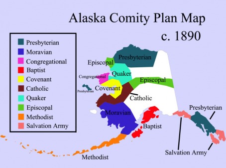
I got tired of searching the internet for a good map of the "Comity Plan" in Alaska which divided Alaska into denominational regions. So I made one. I'm not 100% sure on the exact boundaries, but I think that this is very close to how it worked out. I hope others can find this useful...or at least interesting! Enjoy.
4 Comments
Lucus Levy Keppel
6/24/2017 08:26:08 pm
Thank you so much for posting this! It was exactly the map I was searching for for my Presbyterian Journey class, when talking about the mission boards of the late 1800s. :-)
Reply
Francis
11/2/2021 11:07:46 am
We're using this map to show new state employee's the regions dominate religions. You did an awesome job!
Reply
Angela Linn
5/16/2022 11:35:00 am
The perfect graphic - I'd love to use it in my dissertation, crediting you of course. Please let me know if you would approve of that usage.
Reply
Adam London
5/16/2022 05:12:54 pm
Hi Angela, absolutely, please use it! If you're willing, I'd also love to read your dissertation. Whether you are critical of the church or commend them, I love to read both sides.
Reply
Leave a Reply. |
Archives
December 2016
Contact Us: |